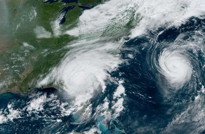
Forecasters at Colorado State University – the group to pioneer seasonal hurricane forecasting in the early 1980s – issued its first outlook for the 2024 Atlantic hurricane season on Thursday. Their outlook calls for an “extremely active” hurricane season in 2024, with 23 named storms, 11 hurricanes, and five hurricanes to reach Category 3, 4, or 5 status, with winds of 111 mph or stronger.
The Atlantic hurricane season runs from June 1 through Nov. 30.
The initial forecast is well above the 1991-2020 average of 14 named storms, seven hurricanes, and three Category 3 or stronger hurricanes. It is the highest spring hurricane outlook ever issued by CSU since the team began April forecasts in 1995.
Though forecasters acknowledge historically lower skill in April outlooks compared to subsequent outlooks issued during hurricane season, they emphasize strong signals favoring storm development which give higher-than-normal confidence for a very active hurricane season ahead.
Unprecedented Atlantic heat wave driving up forecasts
The extreme marine heat wave that began last hurricane season and ravaged Florida’s coral reef system, forcing scientists to add new alert levels to their coral reef monitoring, has continued into 2024 largely unabated. The tropical waters stretching from Africa to the Caribbean – an area known as the Main Development Region or MDR – remain at record levels for the time of year. This week, average temperatures across the MDR topped 79 degrees Fahrenheit, a threshold not typically reached until July.
Although the tropical Atlantic tends to dip to its coolest in early spring, the relentless heat has kept waters near July averages since early February.
Seasonal forecast models indicate no let up in the Atlantic heat wave into the peak months of hurricane season in August, September, and October. CSU forecasters note the pattern of exceptional warmth is a major factor driving up the forecast this year, since warm waters are the primary fuel source powering hurricanes.
El Niño expected to transition to La Niña for this hurricane season
El Niño – the irregular pattern of above-average waters straddling the equator in the eastern Pacific – tends to reduce hurricane formation in the Atlantic. This wasn’t the case in 2023, as the unprecedented Atlantic warmth counteracted the usual strong upper-level winds that accompany El Niño events. Without storm-busting wind shear from El Niño, the 2023 Atlantic hurricane season notched more named storms than any other El Niño year in the modern record, according to NOAA forecasters.
El Niño is quickly fading in the Pacific, having peaked in November and December 2023, and government forecasters anticipate a quick flip to La Niña by late summer as hurricane season ramps up.
A reversal to La Niña – characterized by cooler-than-average waters across the eastern equatorial Pacific – would not only relax upper-level winds across the Atlantic, but also favor storm formation closer to the United States.
Studies show a higher risk of U.S. landfalls when La Niña is present, with nearly twice as many U.S. landfalls during La Niña seasons than during El Niño seasons. For this reason, Colorado State forecasters expect the odds for a major hurricane impact along the U.S. coastline to be higher than average in 2024.
While hurricane season outlooks can give a big-picture look at potential storm activity, they can’t provide critical details such as where hurricanes will go. Some very active hurricane seasons like 2010 recorded no major U.S. landfalls while other less active hurricane seasons like 1992 – the year of Hurricane Andrew – saw generational impacts.
South Floridians should prepare this season as they do every hurricane season. It only takes one bad hurricane to make for a bad season here.
The National Oceanic and Atmospheric Administration (NOAA), the parent agency of the National Weather Service, will release its first seasonal hurricane forecast at the end of May. The next update from CSU will be issued on June 11.
IAmMuffin15 on April 4th, 2024 at 15:18 UTC »
And every retiree in America has lined themselves up like bowling pins in Florida to get hit by the next Category 5
Soren_Camus1905 on April 4th, 2024 at 14:56 UTC »
I'd say people are going to start caring when their insurance premiums start skyrocketing.
Classic case of it's not a problem until it's my problem.
pegothejerk on April 4th, 2024 at 14:33 UTC »
The article is WELL worth reading, there’s multiple indicators that things are not just business as normal, as climate change deniers have constantly claimed any time any prediction like this is made - especially the bit about the region between Africa and the Caribbean recording temperatures right now it usually doesn’t get until July, a source of heat that helps seed these storms.
The forecast at a glance:
For comparison-