Thanks to a new combination of connected satellites, the world’s methane super-emitters can be spotted with “staggering” accuracy and almost real-time. This is a crucial new step in the global fight against climate change. Methane is responsible for a quarter of human-induced global warming and provides a short-term lever on climate change because it remains in the atmosphere for a much shorter time than CO2.
Using a combination of satellites, researchers can now detect methane super-emitters globally with great accuracy and almost in real time.
This allows the identification of major sources of this potent greenhouse gas and is a crucial development for climate change mitigation efforts.
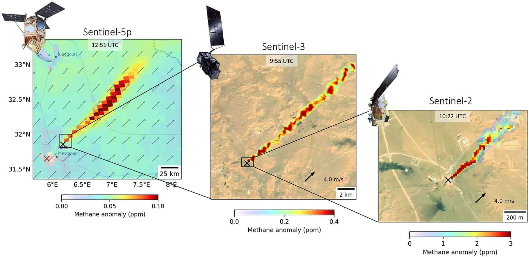
The tiered approach moves from low-resolution global scans by Sentinel-5P to pinpointed spotting of emitters by Sentinel-3 and Sentinel-2 with increasing spatial resolution
ESA’s Copernicus program provides satellite data that enable scientists around the world to monitor climate change and support mitigation efforts. One of the significant challenges is the mitigation of methane, the second most important greenhouse gas contributing to climate change. Combining observations from three Copernicus satellites – Sentinel-5P, Sentinel-3, and Sentinel-2 -now enables researchers to detect and zoom in on methane hot spots in a tiered approach and identify the responsible super-emitters.
Because methane is so important as a cause of human-induced global warming, knowing where the largest methane emissions occur is key to evidence-based decision-making and successful mitigation. Therefore, expectations and hopes were high when the Sentinel 5 Precursor satellite was launched in 2017. The only instrument onboard Sentinel-5P, the Dutch TROPOspheric Monitoring Instrument (Tropomi), was going to scan the entire globe for a range of trace gases, including methane, every day and at city scale (7 x 5.5 km2) resolution. “The results have been staggering”, a report on SRON’s website says. The Dutch space research institute SRON (co-principal investigator of Tropomi) has, for instance, used TROPOMI’s global coverage to find methane emission hot spots worldwide. These Tropomi hot spots have subsequently been targeted with high-resolution (25 meters) observations from the Canadian GHGSat satellites, which can pinpoint the exact sources. In this way, the researchers found many methane super-emitters, varying from fossil fuel facilities to individual landfills.
Support Us! Donate One-time donation Monthly Each quarter Annually Name Email address Currency * AED AUD BGN CAD CHF CZK DKK EUR (€) GBP (£) HKD HRK HUF ILS ISK JPY (¥) NOK NZD PHP PLN RON RUB SEK SGD USD (US$) ZAR Amount () *
== Choose a payment method == iDEAL Card PayPal
I hereby authorize Media 52 B.V. to collect the amount shown above from my account periodically. I hereby agree to the Privacy Policy
From a business park in Noordwijk to an international hotspot for space: NL Space Campus Many Dutch people will be familiar with Space Expo, which attracts over 100,000 visitors in normal years. But less visible is what else happens at the Space Campus.
However, GHGSat observations cannot cover the entire world and only part of the observations are publicly available. The gaps have recently partly been filled with land-imaging satellites such as Sentinel-2, which can detect the largest methane leaks under favorable observing conditions such as over deserts. Sentinel-2’s high-resolution observations (20 m) provide global coverage every 5 days and were designed to provide operational data products for environmental risk management, land cover classification, and land change detection. Sentinel-2 is especially powerful in detecting methane leaks in a tiered approach, where Tropomi Sentinel 5P is used to tip-and-cue high spatial resolution satellites.
The tiered approach has become even more compelling using Sentinel-3, as researchers at SRON Netherlands Institute For Space Research and JPL show in this week’s published paper. Zooming in on an area as large as 7 x 5,5 km2 to pinpoint a fossil fuel facility at Sentinel-2’s resolution can be challenging. Moreover, as Sentinel-2 observes locations only every five days, chances are that short-term methane emissions like gas blowouts escape identification. That is where Sentinel-3 comes in. With daily global coverage and the ability to pinpoint the largest methane point sources to within 500×500 m2 (under favorable observing conditions), Sentinel-3 is the missing link between Tropomi and Sentinel-2. Sentinel-3’s daily global coverage is also particularly important for large leaks that only last a few hours and could easily go unnoticed between Sentinel-2 overpasses.
First map of global methane-emitting landfills to be presented at GOP27 Global Methane Hub, SRON, and GHGSat are mapping the world’s largest methane-emitting landfills. The map contains over a hundred of them.
“The secret is the tiered approach,” SRON-researcher Sudhanshu Pandey (now at JPL) says. “We now have a supergroup of three Copernicus satellites to spot super-emitters of methane very quickly and precisely identify the responsible facilities. Especially super-emitters in desert areas or extremely large emissions can be seen very well with these instruments, zooming in with increasingly high resolution. A fine example of very large but transient emissions that we could examine using the complementary observations happened along a Russian gas pipeline. In our paper, we show that Sentinel-3, combined with Sentinel 5P and Sentinel -2, is a great asset for methane mitigation.”
The tiered use of the three satellites started with a Sentinel-5P observation on 18th June 2021, which showed an apparent methane plume in Russia. Zooming in with Sentinel-3 shows that there are two methane plumes coming from the locations indicated with the white crosses. Further zooming in with Sentinel-2 shows the leaks originate from two facilities along the gas transmission pipeline.
noonemustknowmysecre on August 5th, 2023 at 17:07 UTC »
What can we do about landfills? Giant bubble and compress the gasses on top? Bury it all under a foot of dirt? Light it on fire for an eternal dumpster-fire aesthetic?
mnstorm on August 5th, 2023 at 17:00 UTC »
Shame most comments here are jokes. This is great tech in our next step to shame super-emitters, besides the known petrochemical companies. We need to target and shame or tax them to hell.
MohamedsMorocco on August 5th, 2023 at 13:41 UTC »
"The study covered four landfills, including one in Buenos Aires whose emissions had a climate impact equal to that of 1.5 million cars."
City's name doesn't check out.
Surprised to see so many hotspots in Morocco and Spain, definitely something to work on. This map doesn't include oil and natural gas pumping and transport, which are probably bigger sources of methane.