Factbook photos - obtained from a variety of sources - are in the public domain and are copyright free. Agency Copyright Notice
The image captures an ice covered fjord on Baffin Island with Davis Strait in the background. Image Credit: NASA/Michael Studinger.
The Bay of Fundy, between the provinces of New Brunswick and Nova Scotia, has one of the highest tidal ranges in the world - on average about 17 m (56 ft). At low tide, one can literally walk on the bottom of the ocean.
One would never guess that beyond the island in the fog, which is George's Island, lies the bustling city of Halifax, Nova Scotia.
Peggys Point Lighthouse in Peggys Cove, Nova Scotia is a very popular tourist site operated by the Canadian Coast Guard. The lighthouse, the second one on this site, was built in 1914 and is 15 m (50 ft) tall.
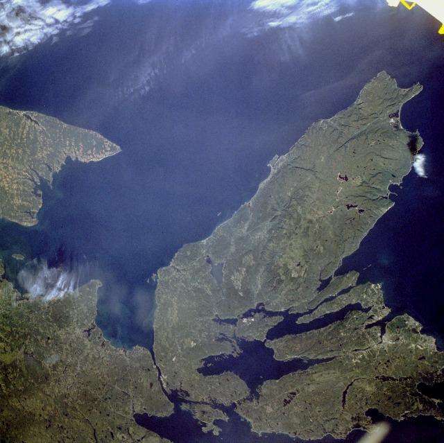
The Canadian maritime province of Nova Scotia can be divided into two separate regions - Cape Breton Island (on the right) and much larger, peninsular mainland Nova Scotia (lower left). Cape Breton Island is joined to the mainland by a causeway and a railroad spanning the narrow Strait of Canso. St. George's Bay is the small bay west of the causeway, and the Northumberland Strait separates Cape Breton Island from the eastern end of Prince Edward Island, another maritime province of Canada (visible along the west margin of the photograph). Photo courtesy of NASA.
A view of Georges Bank, a large elevated area of the sea floor that separates the Gulf of Maine from the Atlantic Ocean. The Bank is situated east of Cape Cod, Massachusetts (US; on the left) and southwest of Cape Sable Island, Nova Scotia (Canada; upper right). Photo courtesy of NASA.
Green Gables farmhouse, Cavendish, Prince Edward Island. The farm and its environs served as the setting for the popular Anne of Green Gables novels by Lucy Maud Montgomery.
A night view of the Montreal metropolitan area is featured in this image from the International Space Station. This photo of the Montreal, Quebec metropolitan area (center) illustrates the extent of urbanization made clearly visible by city lights at night. Major roadways and industrial areas are traced by bright white lighting, while the adjacent residential and commercial land uses are characterized by more diffuse yellow-gold lighting. Rivers and other water bodies appear black, while the surrounding rural countryside is faintly illuminated by moonlight. Blurry areas at top and bottom left are caused by cloud cover. Montreal is the largest city in the dominantly French-speaking province of Quebec, and the second-largest in Canada, after Toronto. While the city of Montreal proper is located on - and almost completely covers - the Island of Montreal at the confluence of the St. Lawrence (center) and Ottawa Rivers (not visible), the city takes its name from Mont Royal located at the city's center. Image courtesy of NASA.
The Montmorency Falls form at the mouth of the Montmorency River as it drops over a cliff shore into the St. Lawrence River. The falls are the highest in the province of Quebec.
What appears to be a stroke of thick red paint in this false-color satellite image is actually a remarkable interplay of light and cloud in the Canadian Rockies. Angling through the mountains is part of the Rocky Mountain Trench, a valley that extends from Montana in the US, to just south of the Yukon Territory in Canada. Low clouds filled a part of the Trench near the border between the provinces of Alberta and British Columbia. The light-reflecting nature of the clouds coupled with low sun elevation resulted in this startling effect. Image courtesy of USGS.
The snow-covered Coastal Mountains of British Columbia are featured in this image taken from the International Space Station. The long smooth areas are glaciers. Photo courtesy of NASA.
Moraine Lake in Banff National Park, Alberta. The intense blue waters of the lake come from the run-off of nearby glaciers.
The white sails of Canada Place in downtown Vancouver. The site serves as a hotel, exhibition, and convention center, as well as a cruise ship terminal.
Temple Anshe Sholom in Hamilton, Ontario is the first Reform synagogue in Canada.
Inside one of the six conservatories at Allan Gardens, a park and indoor botanical garden in Toronto. Opened in 1860, Allan Gardens is one of the oldest parks in Toronto; it is named after a former mayor and senator who donated the land to the city.
The historic Church of the Redeemer on the northeast corner of Bloor St. and Avenue Rd. in Toronto was completed in 1879. It is dwarfed by the massive Four Seasons Renaissance Centre.
The mosaic ceiling in the rotunda of the Royal Ontario Museum in Toronto. The inscription in the middle of the dome reads: "That all men may know His work."
An "Old World" floor mosaic of Europe in the Royal Ontario Museum in Toronto.
"The Crystal," the new entrance to the Royal Ontario Museum in Toronto. The ROM is Canada's largest repository of world culture and natural history.
The Ontario Legislative Building in Toronto houses the viceregal suite of the Lieutenant Governor of Ontario, the Legislative Assembly of Ontario, and the offices for members of the provincial parliament.
Extensive wetlands lie near the town of Yellowknife, just north of Great Slave Lake in the Northwest Territories. The hundreds of shallow lakes, shown as black in this false-color satellite image, have formed in grooves in the landscape that were carved by glaciers during the last Ice Age. The red in this image could represent grass or marshland, while the green is taller vegetation, such as shrubs and trees. Image courtesy of USGS.
Akpatok Island, the largest island in Ungava Bay in northern Quebec, dominates this enhanced satellite image. Accessible only by air, Akpatok Island rises out of the water, sheer cliffs soar 150 to 245 m (500 to 800 ft) above the sea surface. The island is uninhabited, except for a Dorset (paleo-Eskimo) settlement that was abandoned by 1900 and a defunct exploratory oil drill, built in 1971. The island is an important sanctuary for cliff-nesting seabirds including its namesake the Akpat or the Thick-billed Murre, which nests in the pock-marked cliffs on the northern and southern ends of the island. Numerous ice floes around the island attract walrus and whales, making Akpatok a traditional hunting ground for native Inuit people. Image courtesy of USGS.
During the last ice age, Akimiski Island in the James Bay lay beneath vast glaciers that pressed down with immense force. As the climate changed and the ice retreated, Akimiski began a gradual rebound. The island's slow but steady increase in elevation is recorded along its naturally terraced edges in this false-color satellite image where the coastline seems etched with bathtub rings, the result of the rising landmass and wave action at previous sea levels. Image courtesy of USGS.
Like sweeping brushstrokes of pink and green, the Belcher Islands meander across the deep blue of the James Bay portion of the Hudson Bay. The islands shown in this enhanced satellite image are part of the Belcher archipelago, which is comprised of approximately 1,500 islands and covers an area of 3,000 sq km (1,160 sq mi). The islands' only inhabitants live in the small town of Sanikiluaq, near the upper end of the middle island. Despite the green hues in this image, these rocky islands are too cold - and the soil is too thin - to sustain more than a smattering of low-growing vegetation. Image courtesy of USGS.
two vertical bands of red (hoist and fly side, half width) with white square between them; an 11-pointed red maple leaf is centered in the white square; the maple leaf has long been a Canadian symbol
Background: A land of vast distances and rich natural resources, Canada became a self-governing dominion in 1867, while retaining ties to the British crown. Canada repatriated its constitution from the UK in 1982, severing a final colonial tie. Economically and technologically, the nation has developed in parallel with the US, its neighbor to the south across the world's longest international border. Canada faces the political challenges of meeting public demands for quality improvements in health care, education, social services, and economic competitiveness, as well as responding to the particular concerns of predominantly francophone Quebec. Canada also aims to develop its diverse energy resources while maintaining its commitment to the environment.
Military expenditures: 0.99% of GDP (2016) 0.99% of GDP (2015) 1% of GDP (2014) 1% of GDP (2013) 1.12% of GDP (2012) country comparison to the world: 80 Military branches: Canadian Forces: Canadian Army, Royal Canadian Navy, Royal Canadian Air Force, Canadian Joint Operations Command (2015) Military service age and obligation: 17 years of age for voluntary male and female military service (with parental consent); 16 years of age for Reserve and Military College applicants; Canadian citizenship or permanent residence status required; maximum 34 years of age; service obligation 3-9 years (2012)
Akesgeroth on August 5th, 2017 at 17:20 UTC »
Go to Google Maps, switch to satellite view and check out northern Quebec.
Soliloquies87 on August 5th, 2017 at 15:49 UTC »
Each extended family in Canada could probably own their lake.
dont_engage on August 5th, 2017 at 15:33 UTC »
And 20% of the world's fresh water supply!