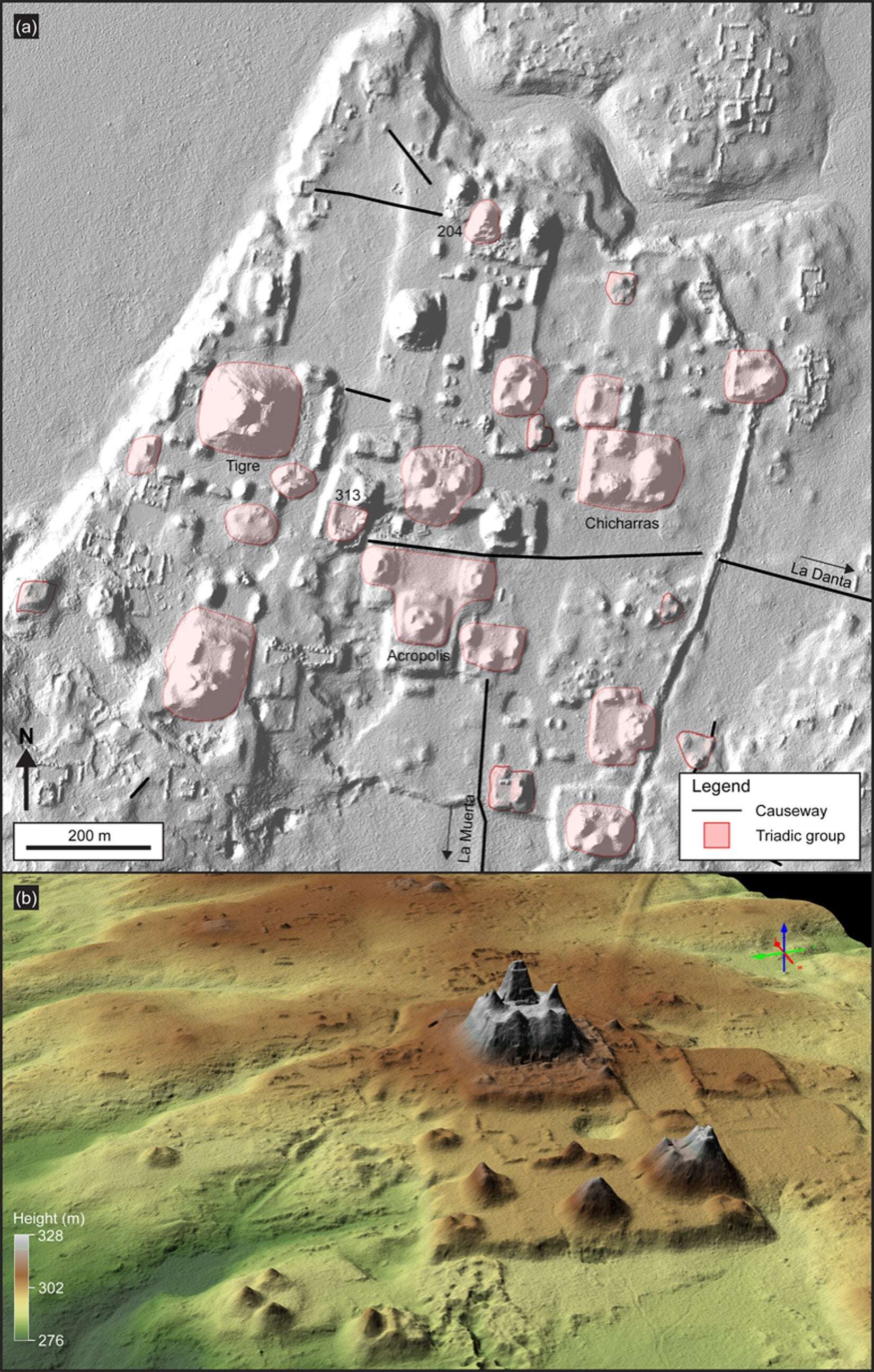
Triadic structures in El Mirador: (a) LiDAR image showing triadic structures in the civic center of El Mirador (Tigre pyramid is the largest in this section of the city); (b) LiDAR 3D view showing the pyramidal complex of La Danta, located on the east side of the civic center at El Mirador. Credit: Ancient Mesoamerica (2022). DOI: 10.1017/S0956536122000244
A team of researchers affiliated with multiple institutions in the U.S., working with a colleague from France and another from Guatemala, has discovered a very large 2,000-year-old Mayan civilization in northern Guatemala. In their paper published in the journal Ancient Mesoamerica, the group describes using LiDAR to conduct a survey of the area.
LiDAR is a detection system similar to radar but is based on laser light rather than radio waves. In recent years, it has been used to scan parts of dense tropical rain forests for signs of ancient civilizations. Lasers used in such systems are able to penetrate vegetative canopies over rain forests, revealing what is on the ground beneath them.
In this new effort, the researchers flew over parts of Guatemala as part of a mapping effort, when they came across what they describe as a vast ancient Maya civilization. In studying their maps, they were able to see that the ancient civilization was made up of more than 1,000 settlements covering approximately 650 square miles, most of which were linked by multiple causeways. The researchers were also able to see that the people who once lived in the settlements had been densely packed—a finding that goes against theories suggesting early Mesoamerican settlements tended to be sparsely populated.
The causeways (cleared, raised beds used as roads) added up to 110 miles of traversable pathways, making it relatively easy for the people in the civilization to visit other settlements. The researchers note that the road network would have allowed for collective labor efforts.
The researchers also found evidence of large platforms and pyramids in some settlements, which, they note, suggests some of them served as centralized hubs for work, recreation and politics. They note also that some of the settlements had ball courts that prior research has shown were used for playing a variety of sports native to the region. The researchers also found that the people of the civilization had built canals for moving water and reservoirs for holding it to allow for use during dry periods.
More information: Richard D. Hansen et al, LiDAR analyses in the contiguous Mirador-Calakmul Karst Basin, Guatemala: an introduction to new perspectives on regional early Maya socioeconomic and political organization, Ancient Mesoamerica (2022). DOI: 10.1017/S0956536122000244
Sea2Chi on December 24th, 2022 at 00:41 UTC »
That area is crazy. I took a taxi from the Guatemalan border to Tikal years ago and the driver explained that the reason the road took so many random turns was they kept running into ruins. Huge parts of the region are covered in ruins that have been overtaken by jungle, so to a layman, it looks like nothing but hills covered in vines and trees. But underneath it's the bones of a dead civilization.
LosFeliz3000 on December 23rd, 2022 at 19:07 UTC »
“the ancient civilization was made up of more than 1,000 settlements covering approximately 650 square miles”
So cool! I wonder what caused it to fade in prominence so long ago? (War or a virus likely?)
Osiris32 on December 23rd, 2022 at 18:25 UTC »
Very, very cool. Archeologists live to discover a previously unknown settlement, finding an entire civilization? Now that's gotta feel really awesome.