Editor’s Note: Affected by the storm? Use CNN’s lite site for low bandwidth. You also can text or WhatsApp your Ian stories to CNN +1 332-261-0775.
Hurricane Ian made landfall along the southwestern coast of Florida near Cayo Costa around 3:05 p.m. ET Wednesday with winds near 150 mph, making it a strong Category 4 hurricane, according to the National Hurricane Center.
The storm is delivering a catastrophic trifecta of high winds, heavy rain and historic storm surge to the state and is set to cause significant power outages and flooding as it moves at a slow pace across central Florida over the next day or two.
Hurricane Ian is tied for the strongest storm to make landfall on the west coast of the Florida peninsula, matching the wind speed of Hurricane Charley in 2004. Florida Gov. Ron DeSantis said Tuesday Ian will rank as one of the top five hurricanes to ever hit the Florida peninsula, behind Hurricanes Andrew (1992) and Michael (2018).
Already, more than 1.3 million Florida utility customers were without power as of 6 p.m., according to PowerOutage.us. Officials in Cape Coral and Punta Gorda reported significant impacts, and the storm surge set records for the highest water levels ever observed in Fort Myers and Naples.
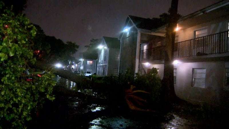
Photos: Hurricane Ian barrels into Florida NOAA/AP A satellite image shows the eye of Hurricane Ian approaching the southwest coast of Florida on Wednesday, September 28. Photos: Hurricane Ian barrels into Florida Naples Police The streets of Naples, Florida, are flooded on Wednesday. City officials asked residents to shelter in place until further notice. Photos: Hurricane Ian barrels into Florida Pedro Portal/El Nuevo Herald/TNS/Abaca/Reuters Sailboats anchored in Roberts Bay are blown around in Venice, Florida, on Wednesday. Photos: Hurricane Ian barrels into Florida Crystal Vander Weit/TCPalm/USA Today Network Melvin Phillips stands in the flooded basement of his mobile home in Stuart, Florida, on Wednesday. Photos: Hurricane Ian barrels into Florida Bryan R. Smith/AFP/Getty Images A man walks where water was receding from Tampa Bay due to a negative storm surge on Wednesday. Photos: Hurricane Ian barrels into Florida Stephen M. Dowell/Orlando Sentinel/AP Utility trucks are staged in a rural lot Wednesday in The Villages, a Florida retirement community. Photos: Hurricane Ian barrels into Florida Marco Bello/Reuters Traffic lights are blown by strong gusts of wind in Fort Myers, Florida, on Wednesday. Photos: Hurricane Ian barrels into Florida Greg Lovett/The Palm Beach Post/USA Today Network Damage is seen at the Kings Point condos in Delray Beach, Florida, on Wednesday. Officials believe it was caused by a tornado fueled by Hurricane Ian. Photos: Hurricane Ian barrels into Florida Marco Bello/Reuters A TV crew broadcasts from the beach in Fort Myers on Wednesday. Photos: Hurricane Ian barrels into Florida Shannon Stapleton/Reuters Highways in Tampa, Florida, are empty Wednesday ahead of Hurricane Ian making landfall. Several coastal counties in western Florida were under mandatory evacuations. Photos: Hurricane Ian barrels into Florida Wilfredo Lee/AP An airplane is overturned in Pembroke Pines, Florida, on Wednesday. Photos: Hurricane Ian barrels into Florida Joe Cavaretta/South Florida Sun-Sentinel via AP Zuram Rodriguez surveys the damage around her home in Davie, Florida, early on Wednesday. Photos: Hurricane Ian barrels into Florida Ramon Espinosa/AP People play dominoes by flashlight during a blackout in Havana, Cuba, on Wednesday. Crews in Cuba have been working to restore power for millions after the storm battered the western region with high winds and dangerous storm surge, causing an islandwide blackout. Photos: Hurricane Ian barrels into Florida Chris O'Meara/AP Workers board up windows on the University of Tampa campus on Tuesday, September 27. Photos: Hurricane Ian barrels into Florida Yamil Lage/AFP/Getty Images People walk through a flooded street in Batabano, Cuba, on Tuesday. Photos: Hurricane Ian barrels into Florida Chris O'Meara/AP Southwest Airlines passengers check in near a sign that shows canceled flights at the Tampa International Airport on Tuesday. Photos: Hurricane Ian barrels into Florida Ramon Espinosa/AP Maria Llonch retrieves belongings from her home in Pinar del Rio, Cuba, on Tuesday. Photos: Hurricane Ian barrels into Florida Willie J. Allen Jr./Orlando Sentinel via AP Traffic builds along Interstate 4 in Tampa on Tuesday. Photos: Hurricane Ian barrels into Florida Alexandre Meneghini/Reuters A man carries his children through rain and debris in Pinar del Rio on Tuesday. Photos: Hurricane Ian barrels into Florida Alexandre Meneghini/Reuters People drive through debris in Pinar del Rio on Tuesday. Photos: Hurricane Ian barrels into Florida Joe Raedle/Getty Images Frederic and Mary Herodet board up their Gulf Bistro restaurant in St. Pete Beach, Florida, on Tuesday. Photos: Hurricane Ian barrels into Florida Yamil Lage/AFP/Getty Images People stand outside a flooded warehouse in Batabano on Tuesday. Photos: Hurricane Ian barrels into Florida Jim Watson/AFP/Getty Images NASA's Artemis I rocket rolls back to the Vehicle Assembly Building at the Kennedy Space Center in Cape Canaveral, Florida, on Tuesday. The launch of the rocket was postponed due to the impending arrival of Hurricane Ian. Photos: Hurricane Ian barrels into Florida NASA via AP Hurricane Ian is seen from the International Space Station on Monday, September 26. Photos: Hurricane Ian barrels into Florida Ramon Espinosa/AP Waves kick up along the shore of Batabano as Hurricane Ian reaches Cuba on Monday. Photos: Hurricane Ian barrels into Florida Yamil Lage/AFP/Getty Images A Cuban family transports personal belongings to a safe place in the Fanguito neighborhood of Havana on Monday. Photos: Hurricane Ian barrels into Florida Shannon Stapleton/Reuters Local residents fill sandbags in Tampa on Monday to help protect their homes from flooding. Photos: Hurricane Ian barrels into Florida Adalberto Roque/AFP/Getty Images A family carries a dog to a safe place in Batabano on Monday. Photos: Hurricane Ian barrels into Florida Phelan M. Ebenhack/AP People wait in lines to fuel their vehicles at a Costco store in Orlando on Monday. Photos: Hurricane Ian barrels into Florida Mike Lang/USA Today Network Ryan Copenhaver, manager of Siesta T's in Sarasota, Florida, installs hurricane panels over the store's windows on Monday. Photos: Hurricane Ian barrels into Florida Kevin Morales/AP A woman takes photos while waves crash against a seawall in George Town, Grand Cayman, on Monday. Photos: Hurricane Ian barrels into Florida Yamil Lage/AFP/Getty Imagaes A man helps pull small boats out of Cuba's Havana Bay on Monday. Photos: Hurricane Ian barrels into Florida Gregg Newton/AFP via Getty Images Shelves are empty in a supermarket's water aisle in Kissimmee, Florida, on Monday. Photos: Hurricane Ian barrels into Florida Martha Asencio-Rhine/Tampa Bay Times via ZUMA Press Wire Cathie Perkins, emergency management director in Pinellas County, Florida, references a map on Monday that indicates where storm surges would impact the county. During a news conference, she urged anyone living in those areas to evacuate. Photos: Hurricane Ian barrels into Florida NOAA/NASA This satellite image, taken Monday at 1 p.m. ET, shows Hurricane Ian near Cuba. Photos: Hurricane Ian barrels into Florida Andrew West/USA Today Network Sarah Peterson fills sandbags in Fort Myers Beach, Florida, on Saturday, September 24. Photos: Hurricane Ian barrels into Florida Andrew West/USA Today Network Besnik Bushati fills gas containers at a gas station in Naples on Saturday. The station had only premium gas that morning. Prev Next
“The storm surge is very significant. We’re seeing cars and boats float down the street. We’re seeing trees nearly bent in half,” Frank Loni, an architect from California staying in Fort Myers Beach for the storm, said midday Wednesday. “There’s quite a bit of chaos on the streets.”
Water levels in Fort Myers have risen more than 6 feet over the past seven hours and still rising as strong winds continue to push water from the Gulf of Mexico ashore, according to CNN Meteorologist Brandon Miller.
“I’ve been here since the mid-70s, this is actually – by far – the worst storm I have ever seen,” Fort Myers Mayor Kevin Anderson told CNN’s Jake Tapper.
The Collier County Sheriff’s Office, south of Fort Myers, reported people being trapped in their homes, according to the department’s post on Facebook. The Sheriff’s Office said it’s in “call triage mode” and getting numerous calls of people trapped by water.
“Some are reporting life threatening medical emergencies in deep water. We will get to them first. Some are reporting water coming into their house but not life threatening. They will have to wait. Possibly until the water recedes,” the post read.
To make matters worse, the Lee County’s 911 system is down and calls are be rerouted to Collier County Sheriff, according to the post.
“You can’t imagine the calls,” the post read.
A mandatory curfew was also put in place for all of Collier County beginning at 10 p.m. Wednesday and end at 6 a.m. Thursday, the county government tweeted Wednesday.
The Olde Naples Seaport, a community of condos that overlooks the Naples Bay in southern Florida, has been consumed by storm surge, according to video shot by Graham Pederson. Pederson experienced knee-high water trying to escape.
In another video shot from the second floor, wind is seen whipping trees and trucks nearly submerged by the water. Pederson retreated to the second floor to wait out the storm, his brother-in-law Kyle Wendel told CNN.
Florida Gov. Ron DeSantis requested President Joe Biden approve a major disaster declaration for all 67 counties in the state due to Hurricane Ian, his office said in a news release. DeSantis is also requesting that President Biden grant FEMA the authority to provide 100% federal cost share for debris removal and emergency protective measures for the first 60 days from Ian’s landfall.
‘Historic’ storm surge expected to bring extensive flooding
Much of west-central Florida and places inland face disaster: “Historic” storm surge up to 18 feet is possible and could swallow coastal homes; rain could cause flooding across much of the state; and crushing winds could flatten homes and stop electricity service for days or weeks.
“This is a wind storm and a surge storm and a flood storm, all in one,” CNN meteorologist Chad Myers said. “And this is going to spread itself out across the entire state. Everybody is going to see something from this.”
Mandatory evacuations were ordered for flood-prone areas on the coast, and the National Weather Service warned those who stayed behind to move to upper floors in case of rising water levels.
“As this storm passes your community, understand this is still a hazardous situation” because of downed powerlines, misuse of generators and standing water, DeSantis said during a Wednesday evening news conference. Floridians should also brace for flooding events in the northeastern part of the state along the St. Johns River, the governor said.
Images showed extensive flooding in coastal neighborhoods in Naples, where officials asked residents to shelter in place until further notice.
In some areas, such as Charlotte County, Florida, 911 response teams have stopped emergency service due to the high winds and dangerous conditions. Sarasota Mayor Eric Arroyo said on CNN’s “At This Hour” that police officers were being taken off the streets due to the wind speeds and hazardous conditions.
“It is too late to evacuate at this point,” Arroyo said.
• Storm surge: Some 12 to 18 feet of seawater pushed onto land was predicted Wednesday for the coastal Fort Myers area, from Englewood to Bonita Beach, forecasters said. Only slightly less is forecast for a stretch from Bonita Beach down to near the Everglades (8 to 12 feet), and from near Bradenton to Englewood (6 to 10 feet), forecasters said.
Lower – but still life-threatening – surge is possible elsewhere, including north of Tampa and along Florida’s northeast coast near Jacksonville.
• Winds: Southwest Florida is facing “catastrophic wind damage.” Winds near the core of Hurricane Ian could exceed 150 mph, with gusts up to 190 mph, the hurricane center said. Multiple locations, including Sanibel Island, already have recorded wind gusts above 100 mph.
Ian is expected to retain hurricane strength through the day and into tomorrow as the center of the storm moves northeast over the Florida Peninsula, passing close to Orlando and Daytona Beach, before moving back into the Atlantic Ocean Thursday afternoon. Hurricane warnings have been issued for not only southwest Florida but also much of central Florida from coast to coast.
• Flooding rain: Because the storm is expected to slow down, 12 to 24 inches of rain could fall in central and northeastern Florida – including Tampa, Orlando and Jacksonville. That makes for a top-of-scale risk for flooding rainfall across this area.
“Further weakening is expected for the next day or so, but Ian could be near hurricane strength when it moves over the Florida East coast tomorrow, and when it approaches the northeastern Florida, Georgia and South Carolina coasts late Friday, ” the hurricane center says.
Prior to nearing Florida, Hurricane Ian pummeled Cuba on Tuesday, leaving at least two dead and an islandwide blackout.
Since then, residents of Florida’s vulnerable Gulf Coast have been boarding up and leaving in droves on congested highways. More than 2.5 million people were advised to flee, including 1.75 million under mandatory evacuation orders – no small ask in a state with a large elderly population, some of whom have to be moved from long-term care centers.
Storm surge began rising late Wednesday morning – more than 4.5 feet above normal highest tides was recorded before noon in Naples, already higher than the previous record there of 4.02 feet from Hurricane Irma in 2017.
Ian’s center is expected to move over central Florida through Thursday morning. Heavy rain and flooding also is possible in southern Florida, Georgia and coastal South Carolina. The governors of North and South Carolina have already declared states of emergency in their respective states.
Storm warnings have expanded northward to North Carolina, according to the National Hurricane Center’s 5 p.m. update. A tropical storm warning has been extended to Surf City and a tropical storm watch has been issued from north of Surf City to Cape Lookout, North Carolina.
A storm surge watch has been issued north of South Santee River, South Carolina, to Little River Inlet.
Because Ian slowly approached land, the worst conditions could remain over some areas for eight or more hours.
“Widespread, life-threatening catastrophic flash, urban, and river flooding is expected” across central and southern Florida, the hurricane center said.
By late Thursday, Ian is due to emerge over the Atlantic Ocean, where it could strengthen again and affect another part of the US.
Schools, supermarkets, theme parks, hospitals and airports had announced closures. The Navy moved its ships, and the Coast Guard has shut down ports. As winds pick up, gas stations may temporarily run out of fuel, DeSantis said.
Life upended as Floridians prepared for landfall
Sarasota County Sheriff Deputies block the access to a downtown bridge over to the barrier islands as Hurricane Ian approaches Florida's Gulf Coast on September 28. Steve Nesius/Reuters
Law enforcement officials around the state warned that people who stayed behind in evacuation areas cannot expect rescuers to respond to calls for help during the storm when winds are high.
“If you call for help, once we pull (officers) off the road … we’re not coming. … We’re not putting people in peril when (others) didn’t heed the mandatory evacuation order,” Pinellas County Sheriff Bob Gualtieri said Wednesday.
Not everyone moved. Chelsye Napier, of Fort Myers, stayed home with her fiance and cats despite being in an evacuation zone, she told CNN Wednesday. They waited “because we don’t know anyone down here,” and ultimately decided to stay put, she said.
Ian's winds could be catastrophic Category 4: 130-156 mph • Most of the area is uninhabitable for weeks or months. • Power outages last weeks to months. • Fallen trees and power poles isolate residential areas. + Well-built framed homes sustain severe damage. Category 5: 157+ mph + A high percentage of framed homes are destroyed. Source: National Hurricane Center
“If anything happens, we have everything that we need here. We’ve got food, we got water. We have everything that we need here,” she said. “So it’s all OK for right now. We’ll see, though, later on.”
As millions were told evacuate, 176 shelters opened statewide and hotels and Airbnbs opened to people leaving evacuation zones, DeSantis said.
Local governments and state agencies also prepared those living in nursing homes and other senior care facilities to evacuate.
Heather Danenhower, with Duke Energy, walks around utility trucks that are staged in a rural lot in The Villages of Sumter County on Wednesday. Stephen M. Dowell/Orlando Sentinel via AP
Florida has around 6 million residents over the age of 60, according to the state’s Department of Elder Affairs – nearly 30% of its total population. As of Tuesday, all adult day cares, senior community cafes and transportation services in evacuation zones are closed, according to the department.
Authorities also readied services to fan out and respond to calls for rescue and then, in the aftermath of the hurricane, for recovery and repair efforts.
Nearly 400 ambulances, buses and support vehicles were responding to areas where the hurricane was expected to make landfall, according to the governor’s office.
DeSantis activated 5,000 Florida National Guard members for Ian’s response operations, and 2,000 more guardsmen from Tennessee, Georgia and North Carolina were being activated to assist.
Florida urban search and rescue teams also were prepping.
“We have five state teams that are activated with additional five FEMA teams that are in play,” Florida Chief Financial Officer Jimmy Patronis said at a news conference Tuesday night. “We have over 600 resources to bear in addition to these out-of-town teams.”
bierdimpfe on September 28th, 2022 at 19:05 UTC »
MSNBC is showing live footage of nearly submerged cars bobbing around on a street in Naples, and the reporter is saying that they aren't near the worst of it.
JustinChristoph on September 28th, 2022 at 15:02 UTC »
I remember people who didn’t evacuate when hurricane Hugo came in 1989, saying they would ride it out. Those that survived agreed that was a mistake.
astrograph on September 28th, 2022 at 14:02 UTC »
Not looking great
Worried about the storm surge at 12-18’